


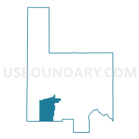
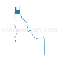
Edgemere Voting District, Bonner County, Idaho
About
Outline

Summary
| Unique Area Identifier | 563816 |
| Name | Edgemere Voting District |
| County | Bonner County |
| State | Idaho |
| Area (square miles) | 97.41 |
| Land Area (square miles) | 95.62 |
| Water Area (square miles) | 1.79 |
| % of Land Area | 98.16 |
| % of Water Area | 1.84 |
| Latitude of the Internal Point | 48.07222350 |
| Longtitude of the Internal Point | -116.79970840 |
Maps

Graphs
Select a template below for downloading or customizing gragh for Edgemere Voting District, Bonner County, Idaho


Neighbors
Neighoring Voting District (by Name) Neighboring Voting District on the Map
- Voting District 055001, Kootenai County, ID
- Voting District 055002, Kootenai County, ID
- Voting District 055003, Kootenai County, ID
- Careywood Voting District, Bonner County, ID
- Cocolalla Voting District, Bonner County, ID
- East Priest River Voting District, Bonner County, ID
- Laclede Voting District, Bonner County, ID
- Oldtown Voting District, Bonner County, ID
- Spirit Valley Voting District, Bonner County, ID
- Westmond Voting District, Bonner County, ID
Top 10 Neighboring County Subdivision (by Population) Neighboring County Subdivision on the Map
- Sandpoint CCD, Bonner County, ID (18,701)
- Spirit Lake-Athol CCD, Kootenai County, ID (14,973)
- Blanchard-Glengary CCD, Bonner County, ID (14,485)
- Priest River CCD, Bonner County, ID (5,293)
Top 10 Neighboring Place (by Population) Neighboring Place on the Map
Top 10 Neighboring Unified School District (by Population) Neighboring Unified School District on the Map
- Lake Pend Oreille School District 84, ID (29,408)
- Lakeland Joint School District 272, ID (26,553)
- West Bonner County School District 83, ID (11,433)
Top 10 Neighboring State Legislative District Lower Chamber (by Population) Neighboring State Legislative District Lower Chamber on the Map
- State House District 3, ID (45,166)
- State House District 1, ID (40,210)
- State House District 2, ID (35,917)
Top 10 Neighboring State Legislative District Upper Chamber (by Population) Neighboring State Legislative District Upper Chamber on the Map
- State Senate District 3, ID (45,166)
- State Senate District 1, ID (40,210)
- State Senate District 2, ID (35,917)
Top 10 Neighboring 111th Congressional District (by Population) Neighboring 111th Congressional District on the Map
Top 10 Neighboring Census Tract (by Population) Neighboring Census Tract on the Map
- Census Tract 2, Kootenai County, ID (8,703)
- Census Tract 9504, Bonner County, ID (6,857)
- Census Tract 1, Kootenai County, ID (6,270)
- Census Tract 9508, Bonner County, ID (5,763)
- Census Tract 9507, Bonner County, ID (4,444)
- Census Tract 9505, Bonner County, ID (3,353)
Top 10 Neighboring 5-Digit ZIP Code Tabulation Area (by Population) Neighboring 5-Digit ZIP Code Tabulation Area on the Map
- 83856, ID (6,340)
- 83801, ID (6,150)
- 83860, ID (6,119)
- 83869, ID (4,161)
- 83804, ID (1,254)
- 83813, ID (1,158)